- Culturally interesting
- Refreshment stop
- Circular route
Brilon Pilgrims' Way 2
St. Michael's Pilgrimage Route
Theme Trail 2: Psalms

Tour starting point:
Church of St. Michael, Gudenhagen
Tour destination point:
Church of St. Michael, Gudenhagen
Properties:
Additional Information
www.tourismus-brilon-olsberg.deCategory
regionaler WanderwegLength
9.1 kmDuration
2:34 hElevation ascent
181 mElevation descent
181 mLowest point
469 mHighest point
564 mCondition
Difficulty
Recommended seasons
The trails start and end at St. Michael's Church and explore different themes over 3.5 kilometers and seven stations (trail 1), 7.5 kilometers and nine stations (trail 2) and 15 kilometers and eleven stations (trail 3):
Path 1 is dedicated to the "Our Father" on the station boards, Path 2 to the"Psalms" and Path 3 is on the theme of"Life's journeys". The paths are intended to offer hikers/pilgrims the opportunity to reflect on themselves in addition to discovering and experiencing nature (directly on the Rothaarsteig); they offer rest and relaxation for body and soul. The theme boards take up the respective path and landscape impulses. The range of trails is complemented by the St. Michael Pilgrims' House, a self-catering house (former rectory) for groups of up to twelve people, located directly next to the church.


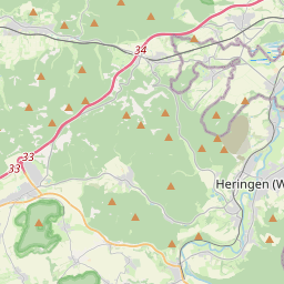


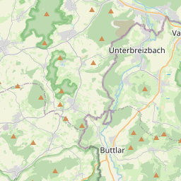
Leaflet © OpenStreetMap contributors
Information
Directions
From the church(1st stop), the path leads downhill and left along the road to Hubertushof. From there, we follow the Waldroute ("W") to the left on a small forest path, which leads steeply uphill after approx. 100 m via a flight of steps. Continue along the path (2nd station) and after approx. 600 m turn right onto a gravel path, after approx. 400 m you reach the road leading to Petersborn. We follow the road to the right, after approx. 150 m turn left at the crossroads onto the dirt road. We follow the path for approx. 700 m until we reach the 3rd station. The path makes a right turn and ends at an asphalt path, turn left there to the 4thstation (approx. 350 m). Continue to the crossroads, then turn right. After approx. 600 m, follow the 2nd path, which turns left and leads below the quarry. Continue left at the fork(5th station). Following the path, we reach the 6th station at the transition from the forest to the meadow. At the end of this path, we pass the small parking lot, cross the asphalt road and continue on a small gravel path in the direction of the "Hiebammen Hütte". At the beginning of the hut area on the left is a bridge with the 7th station. Continue over the bridge and then follow the slightly ascending path towards Petersborn, following the signs for "Rothaarsteig" (horizontal white R on a red background) to the Kyrilltor gate and the landscape window(8th station). From here, return to St. Michael's Church(9th stop).
Equipment
Sturdy shoes
Safety guidelines
Rescue points on the hiking trail posts
Author Tip
...
Literature
Flyer with map section, route description and explanations - available from Brilon Wirtschaft und Tourismus GmbH
Maps
Flyer with map section, route description and explanations - available from Brilon Wirtschaft und Tourismus GmbH
Public transit
Gudenhagen Chapel bus stop
How to get there
Brilon-Gudenhagen, Breslauer Straße
Parking
Church of St. Michael